Saturday 13 January 2024

St Martin's, Shotesham

 It has been a while since I last posted on here and I thought it was time that I updated it and added some new content. While this site was visited in July of 2023 I have sat on it a while and now got round to adding it to my blog.

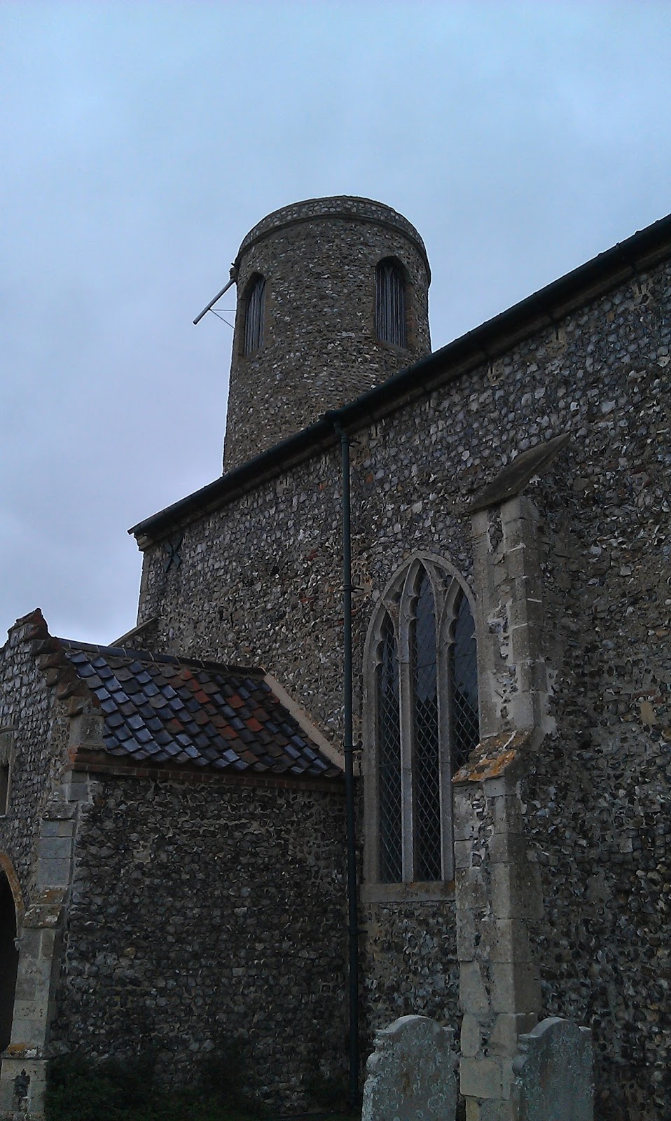
This was a curious little site and I loved walking around it. It is a substantial ruin with much of the tower left and most of the walls of the nave but they are not to full height.

Tower from north side


A little history of Shotesham

While researching the history of the village I found very little informaton. I read multiple sites and articles online to find out as much as possible and included as much as I can below.

So here is a brief history of the village of Shotesham. The village was once thehome and seat of the D'Oyly family who were Baronets until 1773 when the 4th Baron died and the title became extinct. However now the country house and estate at Shotesham and Shotesham Park is the seat of the Fellowes family. 

There is very little evidence to suggest that the land was inhabited prior to the Anglo-Saxon period, with the name of the village being the only remenant of the Anglo-Saxon period to survive. Even the name creates much debate as to its meaning and origin. However Shotesham does appear in the Domesday Book of 1086 and lists the various landowners in and around the village. Those included The Abbott of St Benet's and the Abbott of Bury St Edmunds.

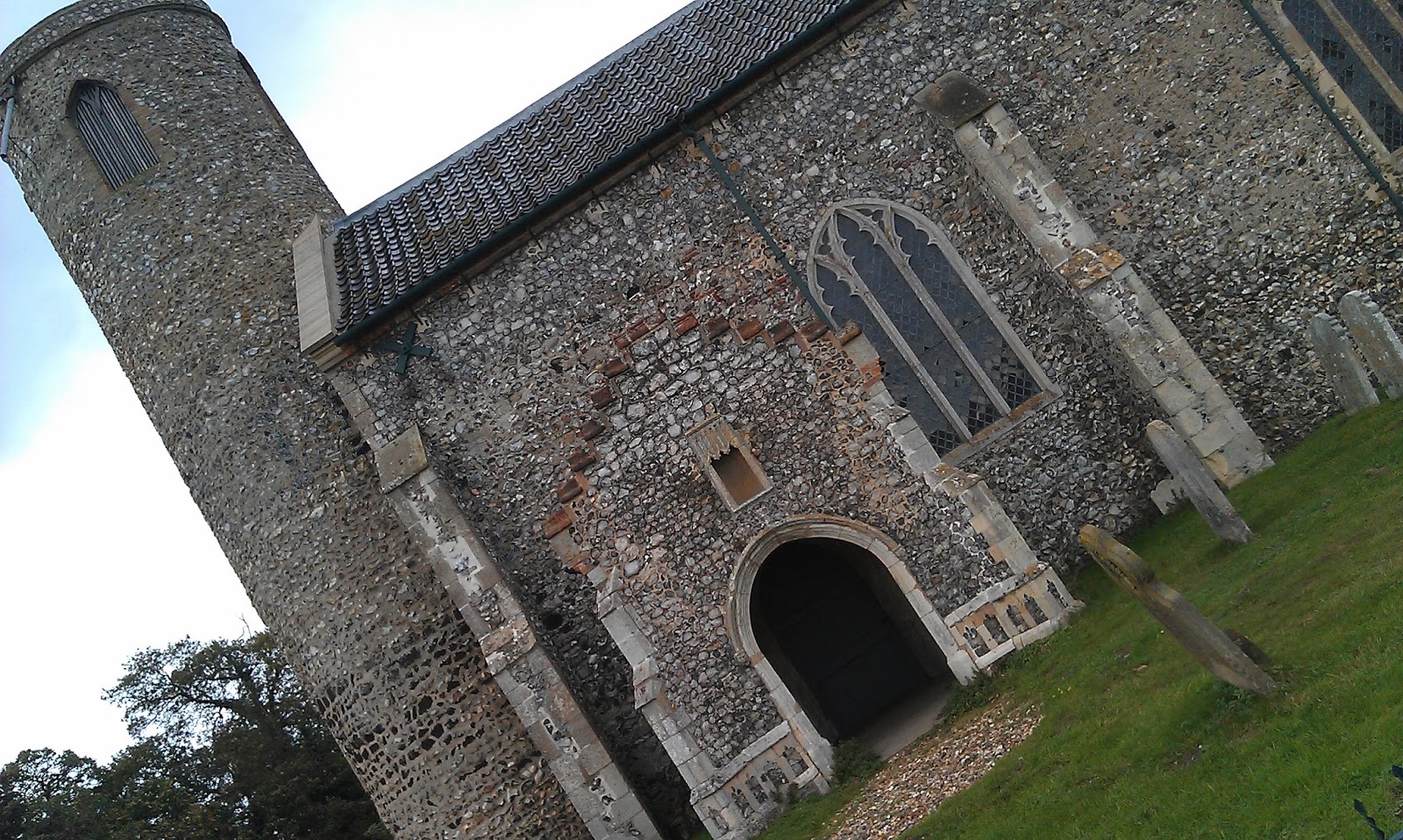
Exterior of south wall of nave

Yet while the village was small and little was recorded about it we do know that it once had four parishes for the fact that it once had four churches. St Martin's, St Mary's, St Botolph's and All Saints. This entry is focusing on St Martin's.


Background reading and information credited to Sara Webber author of A Brief History of Shotesham article available at http://shotesham.com/a-brief-history-of-shotesham/


Church of St Martin's, Shotesham

The ruins of this church are all that remains of the medieval building that once stood here. It is believed that the church was constructed during the 11th Century with records indicating that ownership of this church was given to the Abbott of St Benet's. Further records indicate that it was partially destroyed during the dissolution of the monastries by King Henry VIII. Further destruction of the church occurred during the English civil war. 

Look to west end and tower inside nave

The church is dedicated to St Martin of Tours, France. He was the the third bishop of Tours having converted to Christianity at a young age. He was born in Pannonia in present day Hungary. 2

From around the 1950s up until around 2009 much of the site was covered in scrub and the ruins overgrown with ivy and brambles. It is also reported and evident from old photographs that the site was covered in trees that had started to grown in the nave.

However in 2009 it was decided that the site should be cleared and the ruins stabilised leaving the site clear and easily accessible to visitors today. The nave walls which stand to around head height were cleared and repaired to ensure they stood proud and safe for visitors to stroll around.

View of north side of east window (Interior)
As mentioned above the walls stand to around head height and have been stabilised with further conservation work being undertaken over time. The tower stands to virtually full height. This church was a wonderful place to explore as it stands on a bend in the road only a few hundred yards from St Mary's which is still in use today. St Martin's was not a very big church, even when in use as a parish church. The church ruins and grounds are still consecrated and are under the care of the Parochial Church Council of Shotesham.

Looking through hole in the tower toward east window
The tops of the walls were covered in a sacking and turf mixture to ensure rain did not ingress into the tops of the walls. Some of the walls had been repointed and new mortar pressed in between the flints. Some stone work remained in the arch of the east window which like the tower stands at almost full height or original full height. Small stumps of wall outline where the original south porch stood. The overall size of the church is small. I estimated that the width of the nave would have been around three metres and the length of it approximately 20 metres. At one point the congregation was around 70 people. 

Background reading and information credited to Shotesham.com. For further information and reading please visit www.shotesham.com and view the dedicated pages about St Martin's.

2.Further information and research credited to wikipedia for information on St Martin of Tours.


My Views

I really enjoyed my visit to this site, the sun was shining and it was such a beautiful place to go. It didn't take long to walk around it but I got a sense of calm and tranquility while walking around. While it is often sad to see churches in such a state of ruin, I did not get a feeling of sadness from this site. More of a feeling of happiness that it had been cleared and was now being tended to ensure it survived for future generations to visit. If such buildings had feelings, I would say this one exuded a feeling of being grateful that it had not been forgotten.


Inside the tower

North wall exterior

The tower

South side of east window arch

South porch looking into the nave

Standing outside the church looking at the nave to the east end


Sunday 26 February 2023

Baconsthorpe Castle

I have visited this site before, many years ago and wandered around this old fortified manor house often known as Baconsthorpe Castle. 


The castle started its life in the 15th Century when the Heydon family bought land from the Bacon family. The castle spent 200 years in the Heydon family's ownership being extended, altered and developed by various members of the family. However the family enjoyed a lavish lifestyle and this lifestyle drew up vast spending causing large financial debt. These debts caused the Heydon family to demolish and sell the castle in about 1650.


The outer gatehouse was still a residence until about 1920.


Initially the Heydon family made their fortunes being prominent lawyers. It is often believed that they Heydon family, particularly John Heydon, shifted allegiances between the two houses at war (War of the Roses) which gave rise to the notion that he was a shifty and ruthless person yet he always seemed to weather the storm and come out unscathed probably using his cunning and knowledge being a lawyer. 


In the later years of Baconsthorpe Castle, the use changed from being just that of a lavish home and estate to that of a factory and lavish home. Sir John Heydon II converted parts of the castle into a textile and wool factory, taking wool and spinning it and producing cloth which was sold all over England and on mainland Europe particularly the Netherlands. 


This produced vast profits for the family which was used to extend the hall further. A new outer gatehouse was built and the parkland surrounding the castle was developed. 


Their fortunes didn't last however and successive generations of the Heydon family increased the debts and were forced to sell off parts of the estate and castle. 


The outer gatehouse of the castle was in use a private residence until 1920 when one of the turrets collapsed. It was known as Baconsthorpe Hall. 


Unfortunately when I last visited the site it was closed to the public awaiting work to be conducted to stabilise the ruins and protect it for future generations to visit and enjoy. However it was a pleasure to visit again and marvel at the extensive ruins, imagining what it must have been like it is hay day. From the grand size and ornate decoration and working of stone, it is clear to see how much money must have been spent on this castle. It was a status symbol to show their power and wealth. 


Background information adapted from English Heritage information boards and website. Further reading and information available at https://www.english-heritage.org.uk/visit/places/baconsthorpe-castle/


Outer gatehouse, a private residence until 1920.

Wednesday 11 November 2020

Norwich Cathedral

While this particular building is not a forgotten history, it is one of my favourite buildings. The sheer size of it makes me stand in awe. I am always amazed at how such a building was built almost a thousand years ago on very little in the way of foundations, on low lying and partially marshy land is still standing today. This magnificent building has withstood attack in the form of revolts, fire, bombings during the second world war and general wear and tear.

Cathedral rising up behind the new hostry building
This particular photo I took one evening as I was walking through the cathedral close, it was an autumn/ winter evening and I was mesmorised by the lights shining up the exterior surface of the bulding casting amazing shadows. The first image below is of the south transept and the second image is of the new hostry building with the cathedral rising up behind in the background.

As I said before, not a forgotten history as it dominates the skyline of the city however I wanted to share the photos I took. This post has however given me an idea of future posts, maybe to explore the cathedral and share facts and findings about the place, some of the lesser known facts about the cathedral, its former life as a priory and the land around it.


I hope you enjoy.

South transept, tower and spire


St Nicholas Hospital, Bury St. Edmunds

 So this entry is coming to you some time after my last post as I felt it was time to refresh the blog and update it a little bit. I came across the photos I took sometime ago, in fact back in 2015. I was on a day out visiting places from my childhood around Norfolk and Suffolk when I came across this site. Having visited Bury St. Edmunds many times before I had never explored this particular area of the town however I am so glad I did on this particular day and I stumbled across a ruin on a fork in the road. 

This ruin looked very much like a church with a grand arched stone window, carefully carved. Flint walls with stone blocks at the ends grew out of the grass to a height of approximately five or six foot. Remains of pillars or decoration could be seen in the form of carved stone pillar bases. 

Knowing nothing of this site I started my usual research on the Internet to see what I could find, I was intriguied by this site and wanted to know more. I was fairly certain that it was monastic in origin however I was uncertain as to what form it was. Was it a church, or maybe it could have been a small abbey, or maybe a buiding linked to the grand abbey at Bury St. Edmunds.

This site is located just outside the town to the east on Eastgate Street.

After sometime of research I found out that the site I explored was once a monastic hospital known as St Nicholas Hospital. It was formed before the year 1224 however an exact date is not known by an unknown abbot of Bury St. Edmunds. It was administered by and consisted of a master, a chaplian and several brethren. 

One of the first recorded entries for the hospital was in 1224. This entry relates to the permission received from King Henry III by the master of the hospital to hold a feast and vigial of the Translation of St. Nicholas. Other entries in history around the hospital have been recorded surrounding pardons and charters which relate to the hospital aquiring land in and around Bury St. Edmunds.

Very little is known about this site, we know it was a hospital but was this a hospital in the sense of a Leprosy hospital, was it to care for the poor and sick. Little information about its use exists. 


My Thoughts on the site

Having stumbled across this site I needed to stop and take a look. I was intrigued and interested to find out more. Unfortunately I was unable to obtain access to the other side of the walls however I explored the side of the walls I could. I took some photos of the wonderful stone and flint work and was very impressed with the old window. It appears as though the walls and stonework are still tended to and repaired when necassary. While the site was not hugh and neither was this particular section of the building it clearly had a monastic tilt to it, it was clear to see that throughout its life it was in someway connected to a monastic life.


Background information and reading with some information contained within this post has been adapted from material at https://www.british-history.ac.uk/vch/suff/vol2/p134


Sunday 6 October 2019

St Lawrence, Beeston St Lawrence

I had driven past this church several times over a period of a couple of years and thought how intriguing it looked. I felt it deserved a visit, so finally one day I stopped which was difficult to say the least as this church stands on the side of a busy main road. It has no carpark and very little verge to pull onto however there is a little country road about 30 seconds past it which has space for one vehicle to pull into.

I walked back to the church and entered the churchyard from the little gateway that opens onto the small grass verge right beside the main road. I approached the beautiful little church along the rough stone pathway. The gorgeous round tower loomed above me.

I entered the church wish to my amazement was unlocked. The old door swung open and to my surprise I was greeted with very little inside. Some of the pews at the rear of the church has been removed and it appeared some restoration work was being conducted on parts of the floor. It was evident that while still consecrated this building was not longer used for active worship. The walls were all white washed and looked very fresh. The vaulting of the ceiling looked as though the local landowners or benefactors from the near by hall had mirrored the ceiling from one of their ballrooms.

It is a real shame this building is no longer used for regular worship as I think it would make a magical and awe inspiring place to hear hymns ring out in praise of God.


Tuesday 5 September 2017

St Mary in the Marsh

So this church has illuded me for some time. I think half of the problem was the fact that the church no longer existed having been demolished in the 1500s, as I expected to see some trace of it in the form of ruins or small flint wall sections however there was no trace of this church. 

Some information about this church had come to my attention and so I discussed it with a couple of my friends and on many occassions we looked over the information about the church and its location to see if we could determine the location with respect to the current buildings.

The information I had come across narrowed down our search to the cathedral close as we had found out that the Church of St Mary in the Marsh had been the parish church for the cathedral close or precinct as it would have been known. The church was used constantly and had been extended and rebuilt over the years until in 1564 it was closed and demolished at which point the materials were sold off. However on the plaque in the cathedral close it says that the church was not demolished until 1775. I ponder that this may have been when the final traces of the building were removed.

However the story does not end there and the parish of St Mary in the Marsh continued after this time and still continues to this day. Rather than redrawing parish boundaries after the church was closed, the bishop of Norwich gave permission for one of the side chapels of the cathedral could be used as the parish church instead. The other interesting point about this is that the font from the church was brought over to the new location and still sits in St Luke's chapel at Norwich cathedral.

Well to finish this post off I can say that during a stroll about looking for more forgotten histories, I came across a plaque within the upper close of the Cathedral displaying the location of the church. This I have to say made me very happy. I had finally found the location of the church I had been searching for, for several months. To my annoyance though, I suddenly realised I had strolled past this plaque several time in search of the site. As they say you find things when you are not looking for them!


Weeting Castle

Weeting castle. An interesting site accessed from a main road. Well you are directed by signs from the main road at a junction near to Brandon. It leads to a small housing estate with old styled housing and cottages on one side of the road and box style bungalows on the other. Following the sign posts it appears that you are working deeper and deeper into the housing estate until one sign points to a dirt track down beside some bungalows.

Following the track you eventually reach a small area of parking with banks on either side. One side leading to the back gardens of the housing estate and the other up to the grounds of the castle.

I walked up the steps to a gate which opened onto a grass path lined or flanked by a black metal fence guiding you down to the ruined structure of Weeting Castle. Not much is left of the structure apart from one end wall of the great hall, some low level walls of other parts of the building and what appears to be a fully intacted ice house.


Some history

Lets jump back to about 1180 when Weeting Castle was originally built. It is recorded that it was the home of the de Plais family who inhabited the castle up to about the late 14th century. It was later abandoned by the Howards who were the Earls of Norfolk. It came to their possession through marriage.

There are many similarities to be found in the remains of Weeting Castle with that of Castle Acre. While it is named Weeting Castle, there is no evidence to suggest that it was ever fortified and it is believed that the moat that once surrounded the site was added in the mid 13th century was merely an ornamental feature designed to show the wealth and power of the de Plais family.

On the site a fairly intacted ice house can be found which was added to the site during the construction of Weeting Hall, which has, unfortunately, since been demolished.

Evidence of the site having been occupied since the Saxon period has been found in the form of pottery, burnt daub and post holes.

My visit to Weeting Castle 

I walked around the site to take in the overall scale of it. One wall almost reaches full height. The earthworks showing the fortifications of the site. The moat, now dry in most parts, still clearly visible encircling the compound. 

While called Weeting Castle, this building was not a castleas we think of them. Weeting Castle was a manor house.

I wandered around the grounds of the castle and came across the ice house. The brick edged doorway now filled with a black metal gate stopping you falling into the pit in which the ice was stored. Unfortunately it is no longer filled with ice but people's waste that they discard there using it like a waste paper bin. 

While it is not a huge castle or site I enjoyed my wander around. It was fairly quiet the day I went, coming across maybe one or two groups of three people. Like myself they were enjoying their wander.

Definitelyworth visiting and once I have finished my adventures around sites I haven't yet visited or explored I shall return one day to visit it again.

Background history information adapted from information available at http://www.english-heritage.org.uk/visit/places/weeting-castle/history/